Roadless Rule Master Source The Research Behind One Voice's Position on the 2001 Roadless Rule
By Jeff Knoll
Last Updated: August 23, 2026
The debate over the 2001 Roadless Area Conservation Rule involves more than roads. It involves wildfire, forest health, wildlife habitat, water quality, recreation, rural communities, Tribal interests, public access, forest planning, and a fundamental question about how nearly 45 million acres of National Forest System land should be managed. One Voice supports rescinding the nationwide 2001 Roadless Rule and returning management decisions to the land-management planning process conducted at the individual national forest level. But supporting rescission does not require ignoring the conservation values of roadless lands or dismissing legitimate concerns about roads and development. It requires understanding exactly what the existing rule does, exactly what USDA is proposing to change, and exactly what the available evidence tells us after 25 years of experience. This Master Source is the factual foundation for One Voice's Roadless Rule project.
What Is Actually Being Proposed? On August 20, 2026, USDA published a proposed rule to rescind the nationwide 2001 Roadless Area Conservation Rule. The current national rule generally prohibits road construction, road reconstruction, and timber harvesting within Inventoried Roadless Areas (IRAs hereafter), subject to limited exceptions. USDA states that rescission would remove the national-level prohibition and return management decisions to individual national forests through their land-management planning processes. Approximately 44.7 million acres are currently governed by the nationwide rule. Idaho and Colorado have separate state-specific Roadless Rules and would not be affected by the proposed rescission. Perhaps the most important fact in the entire debate is this: Rescinding the Roadless Rule does not itself authorize a road, timber sale, OHV route, mine or other ground-disturbing project. Existing forest plans would continue to govern these lands. A forest plan could continue restricting road construction and timber harvest. Future projects would still have to comply with the applicable forest plan, NEPA, and other environmental laws.
Read the 2026 Proposed Rule / 91 FR 53827 Federal Rulemaking Docket FS-2025-0001
How to Use This Master Source Sources are grouped according to the questions they help answer. We use five general source classifications:
PRIMARY GOVERNMENT SOURCE — Federal Register notices, Forest Service environmental analyses, government datasets and formal agency documents.
PEER-REVIEWED RESEARCH — Published scientific research that has undergone peer review.
ORGANIZATION'S OWN RECORD — Statements, reports, grant records or publications produced by an organization describing its own activities.
SECONDARY SOURCE — Reporting or analysis that helps explain primary information but should generally not replace the source.
ADVOCACY SOURCE — Material published to influence policy or public opinion. Advocacy sources are useful for understanding arguments and messaging but should not be confused with independent scientific evidence. Inclusion in this compendium does not mean One Voice endorses the conclusions of a source.
What Is an Inventoried Roadless Area and How Accurate Is the Inventory?
Sources: 2001 Roadless Rule GIS Records, GAO-11-377, 2020 Alaska Roadless Rule FEIS, 2026 Biological Assessments
Type: PRIMARY GOVERNMENT SOURCES
An Inventoried Roadless Area (IRA) is an administrative geographic designation used by the Forest Service. It does not necessarily mean the land is physically road-free today. The current 2026 Forest Service record acknowledges that IRAs contain thousands of miles of existing roads, along with some decommissioned and unauthorized routes. The Forest Service assembled the original national inventory from planning records and earlier roadless inventories, including older RARE II records where applicable. GAO later reported that field offices supplied some of the information to headquarters by converting hand-drawn maps into GIS data. The Forest Service itself cautions users about the spatial accuracy of the current GIS dataset. Source-map scales vary considerably, outside features may not align precisely, and the agency states it does not guarantee the data's accuracy. The underlying planning records, adopted assessments, and RARE II documents remain the controlling source material. Errors and outdated information have already been documented. During the 2020 Alaska Roadless review, the Forest Service corrected ownership and shoreline boundaries, mapping errors, areas incorrectly identified as IRA, and locations where roads or timber harvest had subsequently occurred. Nationally, mapping modernization and corrections have reduced the original approximately 58.5 million-acre inventory to about 58.2 million acres. The Government Accountability Office examined the Forest Service's IRA acreage data in 2011 and classified “total acres within inventoried roadless areas” as “may be potentially unreliable.” GAO did not conclude that the inventory was wrong; rather, it found insufficient assurance to give the dataset an unqualified reliability determination. No recurring independent national audit periodically verifies all IRA boundaries against present-day roads, ownership, development, and modern high-resolution mapping.
Therefore, three concepts should not be confused:
Inventoried Roadless Area — an administrative designation based on official records and maps.
Currently unroaded land — land that physically contains no roads today.
Roadless character — the broader undeveloped characteristics associated with a landscape.
If a nationwide regulatory prohibition continues to depend on an inventory developed from multiple planning eras and mapping technologies, should the Forest Service first verify that the inventory accurately reflects the lands being regulated today? This is not an argument against protecting genuinely roadless landscapes. It argues for accurate data, transparent boundaries, and management decisions based on current conditions.
Primary Sources U.S. Forest Service — 2001 Inventoried Roadless Areas GIS Metadata
Official dataset documentation, including Forest Service cautions concerning spatial accuracy and source-map limitations. Government Accountability Office — GAO-11-377, Federal Land Management (2011)
Assessment of Forest Service land-data reliability, including IRA acreage and description of conversion of field-office maps to GIS. 2020 Alaska Roadless Rule Final Environmental Impact Statement
Documents boundary corrections, mapping errors, ownership changes, and identification of “roaded roadless” areas. 2026 Roadless Rule Rescission Biological Assessments
Documents the current approximately 58.2-million-acre IRA inventory and acknowledges existing roads and other routes within IRAs.
The Original 2001 Roadless Rule
Source: 2001 Roadless Area Conservation Rule — 66 FR 3244
Type: PRIMARY GOVERNMENT SOURCE
The Forest Service finalized the Roadless Area Conservation Rule on January 12, 2001. The stated purpose was to provide "lasting protection" for Inventoried Roadless Areas while managing National Forest System lands within a multiple-use framework. The agency prohibited most new road construction, road reconstruction, and timber harvesting because it concluded those activities presented the greatest national-scale risk of fragmenting roadless landscapes.
Why this source matters This is the authoritative source for understanding what the original rule actually intended. It also documents something often overlooked today: many of the same arguments being made in 2026 were debated in 2000. People opposing the proposed prohibitions argued for local management, motorized access, hazardous-fuels reduction and active forest management. Supporters argued for ecological protection, quiet recreation, habitat conservation and limiting commodity development. The Forest Service documented both perspectives in the final rule. The original rule also recognized semi-primitive motorized recreation as a characteristic of roadless areas and stated that motorized uses could continue where otherwise permitted.
Important historical point The Roadless Rule did not create Wilderness. Roadless areas can contain roads, motorized trails, and mechanized recreation. Wilderness is a separate congressional designation governed by the Wilderness Act.
Read the Original 2001 Roadless Rule
How Much Public Participation Occurred in 2000–2001?
Source: 2001 Final Rule and Record of Decision
Type: PRIMARY GOVERNMENT SOURCE
The original rule involved an extraordinary amount of public participation. The initial Notice of Intent drew approximately 16,000 people to 187 public meetings and generated more than 517,000 responses. The Forest Service later held roughly 430 more meetings related to the proposed rule and Draft EIS. By the end of the process, the agency reported receiving more than 1.6 million comments. This history is important and should be acknowledged. Public support for the original rule was substantial. However, popularity in 2001 does not answer the separate question of whether a national management policy should be reconsidered after 25 years of changing ecological conditions, new scientific evidence, changes to the wildland-urban interface, and development of a modern Forest Service planning framework.
The 2025 Notice of Intent to Reconsider the Rule
Source: USDA Forest Service Notice of Intent — August 29, 2025
Type: PRIMARY GOVERNMENT SOURCE
The 2025 Notice of Intent initiated the current environmental review. It contains several particularly important baseline facts. The Forest Service reported approximately 58.2 million acres of Inventoried Roadless Areas nationally. About 44.7 million acres remain governed by the national 2001 rule, while approximately 9.3 million acres in Idaho and 4.2 million acres in Colorado are governed by state-specific rules. The agency also clarified that "roadless" does not necessarily mean road-free: Thousands of miles of existing roads run through Inventoried Roadless Areas. Approximately half of IRA acreage is within one mile of a road, and 31 percent is within one-half mile of a road. That is critical context for the public discussion.
The 2026 Proposed Rule
Source: USDA Forest Service Proposed Rule — August 20, 2026
Type: PRIMARY GOVERNMENT SOURCE
USDA's preferred action is complete rescission of Subpart B of 36 CFR Part 294. Idaho and Colorado's state-specific rules remain. The proposed rule says existing forest plans would continue governing formerly designated IRAs and explicitly states that the rulemaking does not authorize specific ground disturbance. The Forest Service estimates that existing forest plans, economics, terrain, budgets, and other laws would constrain immediate management changes. For example, approximately 18.2 million acres of the potentially affected environment are presently within forest-plan areas where permanent road construction could be allowed. Still, economics, terrain, conservation objectives, and maintenance obligations would constrain actual construction. Temporary roads are more likely near existing roads. Approximately 4.8 million acres, or 16 percent of forested potentially affected IRAs, occur where current forest plans and physical operability could make additional active forest management possible. Rescission creates management options. It does not predetermine management outcomes.
2026 Draft Environmental Impact Statement
Source: 2001 Roadless Rule Rescission Draft Environmental Impact Statement
Type: PRIMARY GOVERNMENT SOURCE
The Forest Service evaluated three alternatives:
Alternative 1 — No Action: Retain the national 2001 Roadless Rule.
Alternative 2 — Proposed Rule: Rescind the national Roadless Rule.
Alternative 3 — Modified Boundaries: Remove national Roadless Rule restrictions in selected roaded areas and portions of the wildland-urban interface while retaining national Roadless Rule protections elsewhere.
The complete DEIS record includes:
Volume I — Environmental analysis
Volume II — State maps
Volume III — Agency letters USDA Forest Service Roadless Rule Information Center
Wildfire: What the Original Rule Predicted
Source: 2001 Final Rule
Type: PRIMARY GOVERNMENT SOURCE
Wildfire was explicitly considered in 2001. At the time, the Forest Service said its existing suppression organization successfully kept approximately 98 percent of starts in IRAs small. It acknowledged that roads could increase human-caused ignition opportunities and predicted that prohibiting additional road construction would not increase either total acres burned or the number of large wildfires. The agency also concluded that extensive fuels work in IRAs generally would not be necessary for at least 20 years, because higher priorities existed elsewhere and the wildland-urban interface and readily accessible municipal watersheds were then thought to occur relatively infrequently near IRAs. That prediction was based on information available in 2000. It should be evaluated against what subsequently occurred—not treated as a permanent scientific conclusion.
Wildfire Conditions 25 Years Later
Source: 2025 Forest Service Notice of Intent Type:
PRIMARY GOVERNMENT SOURCE
The Forest Service now reports materially different conditions. Between 1984 and 2024, approximately 5.5 million IRA acres experienced moderate- or high-severity wildfire. Moderate- and high-severity fire increased particularly after 2000. Approximately 40 percent of IRA lands now have high or very-high wildfire hazard potential. Approximately 23 percent are within the wildland-urban interface (WUI), with additional IRA acreage immediately adjacent to the WUI. These figures do not prove that the Roadless Rule caused worsening wildfire conditions. They do demonstrate that the conditions facing land managers today differ from assumptions made when the rule was adopted. However, changes in overall forest management influenced by multiple federal policy decisions may have increased the size and intensity of wildfires.
National Wildfire Frequency and Acres Burned
Source: National Interagency Fire Center — Wildfires and Acres
Type: PRIMARY GOVERNMENT DATA
NIFC maintains the national record of wildland fire occurrence beginning in 1983. The data reveal an important distinction between how many fires occur and how much land burns. Using the complete NIFC annual dataset:
1983–2000 average: approximately 71,019 wildfires and 3.22 million acres burned per year.
2001–2025 average: approximately 68,808 wildfires and 6.88 million acres burned per year.
That represents roughly a 3 percent decline in average annual fire count but a 113 percent increase in average annual acres burned.
Climate, drought, vegetation, fuels, weather, federal policy, suppression history, ignition sources, and many other variables influence wildfire behavior. NIFC Wildfires and Acres Dataset
Do Roads Increase Wildfire Ignitions?
Yes. The evidence suggests they can.
Source: Aplet, Hartger & Dietz — Fire Ecology, 2026
Type: PEER-REVIEWED RESEARCH
A 2026 nationwide analysis examined Forest Service wildfire ignitions from 1992 through 2024. Ignition density was:
1.75 fires per 1,000 hectares in Wilderness
1.97 in Inventoried Roadless Areas
3.50 in other National Forest lands away from immediate road buffers
7.99 within 50 meters of roads
The researchers concluded that ignition density decreased as distance from roads increased. The study's authors are affiliated with The Wilderness Society,and the study states that The Wilderness Society funded it. That does not invalidate peer-reviewed research, but it is relevant disclosure when assessing a contentious policy study. Use your own best judgment.
Are Fires That Start in Roadless Landscapes Larger? Often, yes.
The same 2026 Fire Ecology study found mean fire size varied considerably:
49 hectares for fires starting within 50 meters of roads.
135 hectares for fires starting in IRAs.
239 hectaresfor fires starting in Wilderness.
However, the study also found that when examining the largest 2 percent of fires, average sizes were similar regardless of origin. A simplistic statement that "roadless fires are always larger" goes beyond the evidence. Roaded landscapes experience substantially more ignitions, while fires beginning in less accessible landscapes tend to be larger on average. The very largest escaped fires can become large regardless of where they start.
Roadless Versus Roaded Wildfire; Western United States
Source: Johnston et al. — Environmental Research Letters, 2021
Type: PEER-REVIEWED RESEARCH
This study compared roaded and roadless portions of western National Forests between 1984 and 2018. The Authors found that about 30 percent of roadless landscapes burned, compared with approximately 18 percent of roaded landscapes. Approximately 4 percent of roadless ignitions escaped initial control compared with approximately 1.4 percent of roaded ignitions. Escaped fires originating in roadless areas were approximately one-third larger on average. However, after accounting for biophysical differences, the researchers found no significant difference in wildfire severity between roadless and roaded landscapes. They further argued that greater fire extent in some roadless landscapes could provide ecological resilience in fire-adapted ecosystems. Ignition, extent, fire size, severity, ecological effects, and suppression success are different questions.
Does the Roadless Rule Prevent Wildfire? The evidence does not support that simple claim.
The strongest evidence favoring roadlessness shows that fewer roads generally mean fewer opportunities for human-caused ignition, but that does not mean the Roadless Rule "prevents wildfire." Wildfires still occur through lightning and other ignition sources. Fires in less accessible landscapes may escape initial attack and grow larger. Wildfire is an ecological process that can produce both beneficial and destructive effects, depending on ecosystem, intensity, timing, and location. Roadlessness reduces exposure to some human-caused ignition sources, while road access can improve management, treatment, and suppression opportunities. Both effects exist.
A Major Counterpoint: Forest Service Research on Roadlessness
Source: Sean Healey — Environmental Research Letters, 2020
Type: PEER-REVIEWED RESEARCH / FOREST SERVICE RESEARCH
Healey examined nearly two decades of forest-health information following adoption of the Roadless Rule. The study found that lack of roads had not prevented fuels-management activities inside IRAs. By area, treatments occurred frequently, although individual treatments in roaded landscapes generally covered more acreage. It also found that roaded and roadless forests had burned at broadly similar rates over the study period. Road proximity was strongly associated with invasive plants; nonnative plants were approximately twice as common within 500 feet of roads as farther away. The study concluded that available monitoring evidence did not support the broad proposition that eliminating road restrictions alone would necessarily improve forest health. Managers should be able to determine when access, treatment, or other management tools are appropriate for a particular landscape.
Does Active Forest Management Reduce Wildfire Severity? Strong evidence says that properly designed treatments can.
Source: Davis et al. — Forest Ecology and Management, 2024
Type: PEER-REVIEWED RESEARCH / FOREST SERVICE RESEARCH
A large meta-analysis of western U.S. conifer forests found strong evidence that: mechanical thinning combined with prescribed burning;mechanical thinning combined with pile burning; andprescribed fire alone reduced subsequent wildfire severity. Across the studies analyzed, these treatments reduced severity by approximately 62 to 72 percent relative to untreated areas. Thinning without surface-fuel treatment was less effective, and treatment effectiveness generally diminished over time. A separate long-term experimental study published in Fire Ecology found that thinning combined with prescribed fire produced the lowest subsequent wildfire severity and remained effective even many years after treatment. These studies demonstrate that fuels treatments can work. They do not establish that every IRA needs treatment or that road construction is necessary for every effective treatment. Management decisions remain landscape-specific.
What Does the Forest Service Say About Roads and Fire Today?
Source: 2026 Cost-Benefit Analysis
Type: PRIMARY GOVERNMENT SOURCE
The Forest Service's own economic analysis presents the wildfire issue as a tradeoff. It states that more road construction and public access could increase the risk of human-caused ignition. At the same time, rescission could increase opportunities for mechanical treatment and strategically placed roads that improve wildfire-control capability in some high-risk locations. The amount of wildfire-risk reduction that would actually result from rescission has not been quantified. The Roadless Rule is neither the cause of America's wildfire problem nor a proven solution. Rescission would give land managers additional tools, but they should use them where science and local conditions justify them.
Recreation Already Occurs Inside Roadless Areas
Source: Forest Service Economic Analysis
Type: PRIMARY GOVERNMENT SOURCE
Inventoried Roadless Areas are not recreation-free landscapes. The Forest Service specifically identifies:
Hiking;
Backpacking;
OHV use;
Snowmobiling;
Cross-country skiing;
Snowshoeing;
Boating;
Hunting;
Fishing; and wildlife viewing among recreation occurring in these landscapes.
For non-Wilderness portions of forests containing potentially affected IRAs, the agency estimates approximately 39 million trail-based and dispersed-recreation visits and another 10 million fishing, hunting, and wildlife-viewing visits. It estimates substantial economic benefits associated with those recreation opportunities.
OnX's Motorized Route Analysis
Source: OnX Roadless Rule Map & Public Comment Guide
Type: ORGANIZATION'S OWN ANALYSIS / ADVOCACY SOURCE
OnX conducted its own overlay of recreation data and Roadless Rule boundaries. It reports approximately: 7,201 miles of full-size motorized trails and primitive roads 2,494 miles of ATV/SxS trails 2,167 miles of motorized singletrack 1,295 miles of snowmobile trails OnX also reports that only about 3 percent of the historical wildfire ignition points in the dataset it analyzed occurred within Roadless Rule areas. It uses that statistic, combined with research linking roads and human-caused ignition, to support retaining the Roadless Rule. This statistic should be treated carefully. The percentage of nationwide ignition points occurring within IRAs is not by itself a controlled comparison of equivalent acreage, vegetation, climate, accessibility, or fire environment. More rigorous peer-reviewed studies comparing ignition density likewise find fewer ignitions in roadless landscapes, so the general relationship is credible. But the "3 percent" figure should not be interpreted as proof that the Roadless Rule itself prevents 97 percent of wildfires.
Economics of Recreation
Source: Forest Service Cost-Benefit Analysis
Type: PRIMARY GOVERNMENT SOURCE
The Forest Service estimates the economic benefit of recreation across National Forest units containing potentially affected IRAs at about $15 billion annually. Its proportional estimate for potentially affected IRA acreage produces economic benefits of up to approximately $1.5 billion for trail-based and dispersed recreation and $419 million for hunting, fishing, and wildlife viewing. The agency also estimates that some recreation users could experience losses if future roads or vegetation treatments alter solitude, scenery, or backcountry settings. The Cost-Benefit Analysis estimates possible annual recreation benefit losses of up to approximately $6.1 million, although the agency acknowledges uncertainty about where and how future projects would occur. Motorized recreation should not dismiss the economic value of quiet recreation. Likewise, economic analysis of roadless lands should not treat motorized recreation, snowmobiling, and road-based access as though they have no value. A multiple-use agency must consider both.
Environmental Safeguards After Rescission
Sources: Proposed Rule, USFWS Biological Assessment and NMFS Biological Assessment
Type: PRIMARY GOVERNMENT SOURCES
One common misconception is that rescission removes environmental laws from these lands. It does not. The USFWS Biological Assessment describes rescission as a framework programmatic action. It establishes a framework but does not authorize future projects. Future actions affecting listed species would continue to require Endangered Species Act compliance and consultation. Wilderness and other statutory protections remain. The NMFS Biological Assessment reaches the same fundamental conclusion for aquatic species and Essential Fish Habitat: subsequent actions remain subject to project-level consultation, applicable Best Management Practices and forest-plan requirements. Environmental Effects Should Not Be Minimized The biological assessments also contain an important warning. The Forest Service anticipates that rescission would increase the likelihood of road construction and timber harvest in some currently protected areas. It acknowledges that some future projects may adversely affect ESA-listed species or designated critical habitat. Those future effects would have to be addressed through project-level environmental review and consultation.
Roadless Rule Exceptions and Actual Management
Source: USFWS Biological Assessment
Type: PRIMARY GOVERNMENT SOURCE
The rule includes exceptions for public health and safety, ecosystem restoration, certain rights, and other circumstances. But the rule itself anticipated that tree-cutting exceptions would be used infrequently. Forest Service records from 2018–2025 show approximately 188 documented projects receiving Roadless Rule exceptions at the tracked level. Around 10 percent involved roads and 96 percent involved tree cutting; some involved both. The agency also says no complete national database tracks every Roadless Rule exception, which limits our ability to quantify the rule's practical effects. Forest Service activity records report approximately 1.8 million acres of hazardous-fuels reduction inside IRAs, but more than half of that figure was classified as wildfire use, and roughly one-quarter came from prescribed burning. It should therefore not be described as 1.8 million acres of mechanical fuels treatment.
Tribal Concerns
Source: USDA Tribal Summary Impact Statement
Type: PRIMARY GOVERNMENT SOURCE
Most Tribal governments participating in consultation opposed full rescission. Concerns include:
Tribal sovereignty and treaty interests;
Sacred and cultural sites; subsistence resources;
Fisheries and water quality;
Increased public or industrial access;
The administrative burden of having to participate repeatedly in project-level reviews; and
Adequacy of government-to-government consultation.
An Alaska Native Corporation, Chugach Alaska Corporation, supported rescission, citing economic development and access concerns.
Idaho: Proof That Roadless Management Does Not Have to Be One-Size-Fits-All
Source: 2008 Idaho Roadless Rule
Type: PRIMARY GOVERNMENT SOURCE
Idaho replaced the national rule with its own state-specific Roadless Rule covering approximately 9.3 million acres. Instead of placing every acre under one identical management prescription, Idaho uses five management themes ranging from highly protective to more flexible:
Wild Land Recreation
Special Areas of Historic or Tribal Significance
Primitive
Backcountry/Restoration
General Forest, Rangeland and Grassland
Each provides different management direction for roads, timber and other activities. Idaho demonstrates that roadless conservation and management flexibility can coexist. Evidence against the assumption that the only choices are either a uniform national prohibition or unrestricted development.
Colorado: Another State-Specific Model
Source: Colorado Roadless Rule Type:
PRIMARY GOVERNMENT SOURCE
Colorado developed its own rule covering approximately 4.2 million acres. The Forest Service describes the rule as a collaborative effort designed to conserve roadless characteristics while addressing Colorado-specific concerns. Those state-specific concerns explicitly included: wildfire risk to communities and municipal water;energy and mineral development;water infrastructure;utility access; andski-area management. Some Colorado acres receive protections more restrictive than the national rule, while other categories provide additional management flexibility. The existence of both the Idaho and Colorado rules demonstrates that differentiated management is already part of federal Roadless policy. The United States does not actually operate under one perfectly uniform national Roadless regime today.
Alaska: A 25-Year Policy Experiment
Sources: 2020 Alaska Roadless Rule FEIS and 2023 Determination of NEPA Adequacy
Type: PRIMARY GOVERNMENT SOURCES
Alaska provides an unusually valuable history because the Tongass has moved repeatedly between different Roadless policies. The 2020 Alaska FEIS evaluated six alternatives after Alaska petitioned USDA for an Alaska-specific rule. The 2020 process ultimately exempted the Tongass from the national rule. In 2023, USDA reversed that policy and restored the 2001 Roadless Rule. Alaska should not be used as simplistic proof that rescission automatically creates jobs or economic growth. The 2023 review concluded that the Roadless Rule itself was not the primary driver of historic changes in Tongass timber production, employment or income. Market conditions, timber demand, other regulations and numerous economic factors mattered. Alaska instead demonstrates how dramatically different regions can generate very different views about the appropriate balance between conservation, community development, subsistence and access.
The Roadless Rule's Institutional History
The Roadless Rule did not emerge in a political vacuum. Understanding the advocacy structure surrounding its creation and defense is a legitimate part of understanding the policy. But relationships must be described accurately.
Pew Charitable Trusts and the Heritage Forest Campaign
Source: The Pew Charitable Trusts' Own Publications
Type: ORGANIZATION'S OWN RECORD
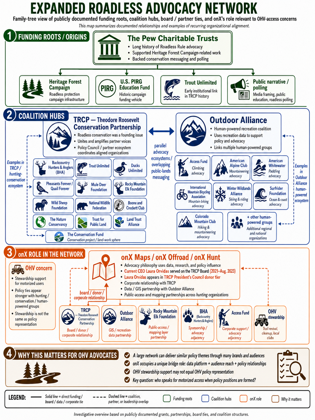
Pew states that it created the Heritage Forest Campaign in 1998 and that the campaign successfully advocated for creation of the 2001 Roadless Rule. Contemporary reporting in 1999 likewise described the Heritage Forest Campaign as an organization created largely at Pew's instigation to advocate for the Roadless initiative. A 2000 congressional oversight hearing also examined foundation funding of the Roadless campaign. The hearing record stated that Pew had provided more than $3.5 million to the National Audubon Society since September 1998 to organize the Heritage Forest Campaign. Because that statement arose in a contested congressional oversight proceeding, it should be identified as a statement in the hearing record, rather than treated as an independently adjudicated filing. Pew's involvement in Roadless policy is not speculative. Pew itself describes the Heritage Forest Campaign as a campaign it created and credits it with helping establish the Roadless Rule.
Pew Funding After the Roadless Rule Was Adopted
Source: Pew Grant Records
Type: ORGANIZATION'S OWN FINANCIAL RECORD
The advocacy effort continued after 2001. In 2005, Pew reported a $1.8 million grant to the U.S. PIRG Education Fund for the Heritage Forest Campaign specifically to secure protection of the acreage covered by the 2001 Roadless Rule through public education and a media campaign. The same publication reported $1.2 million to Trout Unlimited for the Theodore Roosevelt Conservation Partnership, supporting its national hunting and angling alliance. In 2008, Pew authorized up to $1.75 million for its Heritage Forest Campaign to generate public and policymaker support for roadless-area preservation in at least two dozen states. The same Pew grant record provided $750,000 to Trout Unlimited for the Theodore Roosevelt Conservation Partnership specifically for public education and outreach that included protecting National Forest roadless areas. This establishes a documented historical funding relationship that connects Pew's conservation program, the Heritage Forest Campaign, Trout Unlimited, and TRCP around Roadless policy.
Theodore Roosevelt Conservation Partnership
Source: TRCP's Own History
Type: ORGANIZATION'S OWN RECORD
TRCP was founded in 2002, meaning it was created after adoption of the original 2001 Roadless Rule. It therefore should not be described as an organization that created the original rule. TRCP says roadless conservation became one of its founding issues, and that it worked extensively to defend the national rule and develop the subsequent Idaho and Colorado rules. TRCP describes its organizational model as bringing hunting, fishing and conservation organizations together to identify areas of consensus, coordinate shared priorities and present a "united front" to policymakers. This helps explain why similar policy messages can appear through multiple sporting organizations without assuming those organizations are identical.
OnX and TRCP
Sources: TRCP, onX and Corporate Disclosure
Type: ORGANIZATION RECORDS / PUBLIC CORPORATE RECORD
A documented relationship exists between OnX and TRCP. Laura Orvidas is the current CEO of onX. A 2026 SEC-filed NETGEAR proxy statement identifies her as serving on the Executive Board of Directors and Finance Committee of the Theodore Roosevelt Conservation Partnership. She was a 2021 Presidents Council Donor (+$10,000 donation) TRCP first announced Orvidas as a board member in 2021. OnX and TRCP have also collaborated on public-land advocacy projects, including developing a map of BLM lands potentially available for disposal. Initially: nearly 1.5 million acres threatened. Corrected: roughly 540,000 acres. Then later:“Look at these six million acres marked for potential sale.” Technically true. But those were lands already sitting in ordinary BLM RMP disposal inventories—not six million acres suddenly placed on the auction block by Senator Mike Lee. In April 2026, TRCP presented conservation awards to OnX founder Eric Siegfried and CEO Laura Orvidas for their public-land access and conservation work. OnX and TRCP have a substantial, documented institutional relationship. OnX has an estimated 10X multiplier of Annual Revenue generated by its Hunt product vs. its Offroad Product. You can decide if OnX Offroad is a product you wish to support.
Current OnX Roadless Messaging
Source: onX Roadless Rule Campaign
Type: ADVOCACY / ORGANIZATION'S OWN ANALYSIS
OnX has created a Roadless Rule information campaign, interactive mapping tools, and a comment guide. Its materials highlight the conservation benefits of retaining Roadless protections and present wildfire and habitat evidence supporting continued restrictions. The Broader Sporting Conservation Network TRCP maintains a large partner network containing many recognizable hunting, fishing, and conservation organizations. Its current partner list includes organizations such as Backcountry Hunters & Anglers and Boone and Crockett Club, among many others. TRCP explicitly says partnership is designed to facilitate collaboration and shared policy priorities, but it also cautions that partnership does not necessarily mean every organization participates in every TRCP initiative.
The Evidence-Based One Voice Position
Should one national regulatory prohibition adopted in 2001 continue to make the threshold management decision for tens of millions of acres, or should today's Forest Service use modern science, contemporary forest plans, Tribal consultation, public participation, and site-specific environmental review to determine the appropriate management of individual landscapes?
One Voice supports the second approach. The Idaho and Colorado Roadless Rules already demonstrate that different landscapes can receive different levels of protection and management flexibility. Modern forest planning can protect places that should remain intact while allowing access, restoration, fuels work, emergency response, or other activities where local conditions justify them.
Rescission is not a decision to build a road. It is a decision about where that decision should be made.
Core Source Library
Federal Regulatory Record 2001 Roadless Area Conservation Rule — 66 FR 3244
The foundational regulation, Record of Decision, public comments, agency rationale, and original wildfire assumptions.
2025 Notice of Intent — 90 FR 42179
Initiated the current reconsideration and contains important IRA, wildfire, road, and WUI baseline information.
2026 Proposed Rule — 91 FR 53827
The authoritative statement of USDA's proposed rescission and its intended legal effect.
2026 Draft Environmental Impact Statement — Volumes I–III
Primary analysis comparing No Action, full rescission and modified-boundary alternatives.
2026 Cost-Benefit Analysis and Regulatory Flexibility Analysis
Primary economic analysis covering recreation, wildfire, timber, roads, minerals and other economic effects.
USFWS Draft Biological Assessment
Analysis of potential effects on federally listed terrestrial and freshwater species and future ESA consultation requirements.
NMFS Draft Biological Assessment
Analysis of salmonids, aquatic resources and federally protected marine/aquatic species.
Tribal Summary Impact Statement
Summary of Tribal consultation, concerns, proposed alternatives and support received during consultation.
Forest Service Data Web Viewer
Interactive mapping companion to the Draft EIS allowing examination of IRA boundaries, alternatives and relevant landscape layers. Forest Service Roadless Information Center Official Public Comment Docket
Wildfire Data and Research National Interagency Fire Center — Wildfires and Acres
Primary national fire-count and acres-burned dataset. NIFC Wildfire Statistics
Aplet, Hartger & Dietz, 2026 — Fire Ecology
Nationwide comparison of wildfire ignition density and fire size relative to roads, IRAs and Wilderness.
Johnston et al., 2021 — Environmental Research Letters
Western National Forest comparison of fire ignition, escape, extent and severity in roaded versus roadless landscapes.
Healey, 2020 — Environmental Research Letters / USDA Forest Service
Long-term analysis of roads, fire, management activity, invasive plants and overall forest health.
Davis et al., 2024 — Forest Ecology and Management
Meta-analysis of mechanical thinning, prescribed fire and subsequent wildfire severity.
Brodie et al., 2024 — Fire Ecology
Long-term experimental evidence concerning thinning, prescribed fire and wildfire severity.
State-Specific Roadless Management 2008 Idaho Roadless Rule
Five management themes applied across approximately 9.3 million acres.
2012 Colorado Roadless Rule
State-specific rule covering approximately 4.2 million acres and accommodating conservation alongside Colorado-specific management concerns. Alaska 2020 Alaska Roadless Rule Final Environmental Impact Statement
Six-alternative review of Roadless management on the Tongass.
2023 Alaska Roadless Rule Determination of NEPA Adequacy
Record supporting restoration of national Roadless protections to the Tongass. Consider these two documents together when discussing Alaska. Advocacy, Funding and Communications The Pew Charitable Trusts — Heritage Forest Campaign history
Pew's own record describing its 1998 creation of the Heritage Forest Campaign and the campaign's role in establishing the 2001 Roadless Rule.
Pew 2005 Grant Record
Documents $1.8 million for the Heritage Forest Campaign through U.S. PIRG Education Fund and $1.2 million through Trout Unlimited for TRCP.
Pew 2008 Grant Record
Documents up to $1.75 million for the Heritage Forest Campaign and $750,000 through Trout Unlimited for TRCP outreach that specifically included Roadless protection.
Theodore Roosevelt Conservation Partnership History
Documents TRCP's 2002 founding, its "united front" organizational concept, and Roadless conservation as an early organizational priority.
onX Roadless Rule Analysis and Mapping Campaign
Useful both for understanding the current pro-Roadless message and for independently documenting substantial existing motorized recreation within IRAs.
onX / TRCP Institutional Relationship
Documented through TRCP records, joint advocacy projects, and public corporate disclosure of onX CEO Laura Orvidas's TRCP board and finance-committee service.
Our Commitment to the Record
Public-land debates become less useful when evidence is selected only because it supports a predetermined conclusion. One Voice will take a different approach. We support rescission of the 2001 Roadless Rule because we believe land managers should have the ability and responsibility to make informed, transparent, site-specific decisions under modern forest plans rather than operate indefinitely beneath a nationwide prohibition adopted a quarter-century ago. Responsible public-land policy should be capable of considering all of those things at the same time. That is why this source library exists, and why it will continue to be updated as the Roadless Rule process moves forward.
Reprint Permission: This article may be shared or republished in full, provided it is reproduced exactly as originally published and includes the author’s byline. No edits, excerpts, rewrites, summaries, translations, artificial intelligence-generated versions, derivative works, or manipulated versions are permitted without prior written permission from the author.
By Jeff Knoll Find me on LinkedIn @ https://www.linkedin.com/in/jeff-knoll-b5632437/
Originally published at: OneVoiceRec.org
© 2026 Jeff Knoll. All rights reserved except as expressly permitted above.